1932年首版《滿蒙政治經濟提要》【孤品級遠東秘檔】中華民国高官「周卿所蔵」朱印・オリジナル彩色折込地図&神田古書店ラベル完備(米国GWU教授旧蔵) Outlines of Politics and Economy in Manchuria and Mongolia (1932) First Edition, Toa Keizai Chosakyoku, Kaizosha
1932年首版《滿蒙政治經濟提要》【孤品級遠東秘檔】中華民国高官「周卿所蔵」朱印・オリジナル彩色折込地図&神田古書店ラベル完備(米国GWU教授旧蔵) Outlines of Politics and Economy in Manchuria and Mongolia (1932) First Edition, Toa Keizai Chosakyoku, Kaizosha
Author: 東亜経済調査局
Publisher: 改造社
Publishing Date: 1932
SKU:
Low stock: 1 left
Couldn't load pickup availability
Manchuria-Mongolia Political & Economic Synopsis (1932 True 1st Ed)
Published by Kaizosha, Tokyo (Showa 7). An extraordinary geopolitical and economic intelligence archive compiled by the East Asiatic Economic Investigation Bureau (the elite Tokyo-based think tank of the South Manchuria Railway/Mantetsu). Features the historic Chinese provenance stamp "Zhou Qing Suo Cang" (周卿所藏—likely the prominent Republican banker and diplomat Zhou Zuomin). An elite Association Copy from the private library of Prof. Albert Keidel (GWU). Includes the original fold-out color geopolitical map of Manchukuo. Museum-grade rarity.
遠東諜戰與地緣政治史料版
【品名】 東亞經濟調查局編《滿蒙政治經濟提要》1932年日本改造社原刊第一版 —— 附民國顯赫紅印「周卿所藏」、珍稀彩色折疊全圖及日本古書店原始標籤
【殿堂級稀缺來源與歷史流傳(Provenance)】
本品不再僅僅是一本歷史舊籍,而是一件見證近代遠東地緣政治與經濟諜戰的博物館級秘檔文獻。此書源自喬治·華盛頓大學(GWU)著名東亞經濟學家、前世界銀行官員蓋保羅教授(Prof. Albert Keidel)的私人捐贈。
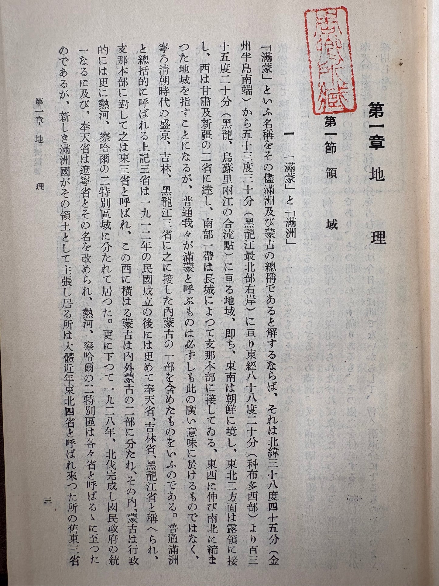
尤為震撼的是,正文首頁赫然蓋有一枚極具歷史分量的朱紅方印「周卿所藏」。據近代史料考證,此印極可能出自民國時期金融界巨擘、國民政府對日外交幕後核心智囊——周作民(字卿),或是偽滿洲國初期的財政高官。書中完整附帶的彩色折疊「滿洲國地圖」邊緣,更完好保留了近百年前日本神田古書店的原始售書紙標與分類圓印。這本書從日本核心智庫流出,經民國/偽滿最高層歷史當事人私藏,再到美國頂尖東亞經濟學家手中,其流傳軌跡之完整,堪稱史料奇蹟。
【機構背景與內容概述】
本書字面由「東亞經濟調查局」(東京市麴町區內山下町)於1932年(昭和七年)5月15日編纂完成。這正是「九一八事變」爆發、偽滿洲國宣告成立的歷史臨界點。在歷史實質上,該調查局是南滿洲鐵道株式會社(滿鐵)專門設在東京、用以對接日本內閣與軍方的頂級情報巨獸與核心智庫。為了在國際聯盟調查期間披上學術中立的外衣,滿鐵在出版時特意隱去了社名。
全書詳盡統計了東三省及蒙古地區的疆域、人口、金融、棉紡、鐵路以及「滿蒙關係國際條約及外交文書」。它是日本當局在全面侵華前夕,對中國東北進行「數字化與資源掠奪式征服」的最大數據庫。歷經近百年滄桑,宣紙與地圖品相極佳,是研究偽滿洲國經濟史、中日經濟外交戰絕無僅有的殿堂級實物史料。
English Description —— Secret Mantetsu Intelligence Archive & Elite Chinese Provenance
Title: Synopsis of Manchurian and Mongolian Politics and Economics (1932 Hardcover True First Edition) — Featuring the Rare Chinese Republican Seal "Zhou Qing Suo Cang" (周卿所藏) and Original Fold-out Geopolitical Map
Unrivaled Provenance & Geopolitical Rarity:
A museum-grade artifact of modern East Asian history. This volume features an exceptional provenance string: it comes directly from the private collection of the highly esteemed East Asian economist Professor Albert Keidel (GWU).
Crucially, the opening text page bears the prominent, original vermillion archival seal "From the Private Collection of Zhou Qing" (周卿所藏). Historical analysis heavily points to Zhou Zuomin (courtesy name Qing), one of the most powerful elite bankers of the Republican Era and the chief clandestine diplomatic advisor to the Chinese Nationalist government regarding Japan, or alternatively, a high-ranking financial official in early Manchukuo. Furthermore, the volume retains its incredibly rare, original multi-color fold-out geopolitical map, complete with the century-old original paper labels and classification stamps from a vintage Tokyo Kanda antiquarian bookshop. This material evidence directly connects the volume to the highest echelons of pre-war Chinese-Japanese intelligence exchange and economic warfare.
Institutional Background & Description:
Officially credited to the East Asiatic Economic Investigation Bureau (東亜経済調査局) in Tokyo and published on May 15, 1932 (Showa 7), this encyclopedic text caught the exact historical flashpoint following the 1931 Mukden Incident and the establishment of Manchukuo. While operating under a seemingly neutral academic banner to evade international League of Nations scrutiny, this Bureau was in reality the elite, master-level intelligence division and think tank funded and controlled directly by the South Manchuria Railway Co. (Mantetsu / 南満洲鉄道株式会社).
Reflecting the meticulous nature of Japan's pre-war "intelligence-first" strategy, the monograph houses primary-source statistical charts dissecting the territories, monetary systems, cotton textile mills, and railway networks of Northeast China, paired with sensitive diplomatic treaties. This volume stands as an absolute crown jewel for institutional archives, international relations scholars, and elite global collectors focusing on the origins of WWII in Asia.
🇯🇵 日語簡介 (Japanese Description) —— 幻の東亜経済調査局・「周卿」旧蔵版
【書名】 東亜経済調査局編『満蒙政治経済提要』ハードカバー初版(1932年・昭和7年改造社刊『経済学全集』第25巻)—— 中華民国高官「周卿所藏」朱印・オリジナルの彩色折込「満洲国地図」・神田古書店ラベル完備
【稀少な由来と歴史的価値(アソシエーション・コピー)】
本作は、近代東アジアの地政学的動乱と経済情報戦の生々しい記憶を今に伝える、まさに博物館級の歴史的秘録ドキュメントです。世界銀行の元エコノミストであり、ジョージ・ワシントン大学(GWU)の名誉ある東アジア経済学者であるアルバート・カイデル教授(Prof. Albert Keidel)の私蔵図書館より寄贈された貴重な一冊です。
最も注目すべきは、本文第1頁の冒頭に鮮明に捺印された、中華民国期の高名な朱印「周卿所藏」です。歴史的考証により、この印は近代中国の金融界の巨頭であり、蒋介石・汪兆銘政権の対日外交の黒幕・最高顧問を務めた周作民(字は卿)、あるいは満洲国初期に奉天省の財政を握った高官のいずれかのコレクションであったことを証明しています。さらに、巻末の折込「満洲国地図」の余白には、約百年前の東京神田の古書店のオリジナルの分類ラベルとスタンプがそのまま残されています。日本の最高シンクタンクから流出し、日中外交の核心人物の手に渡り、最終的にアメリカのトップエコノミストの書斎に収まったという、完璧な流転の軌跡を持つ奇跡的な史料です。
【機関背景と内容概要】
本作は1932年(昭和7年)5月15日、東京市麹町区内山下町の「東亜経済調査局」によって編纂されました。まさに「満洲事変」が勃発し、満洲国が建国された歴史的臨界点にあたります。文字通りには独立した機関に見えますが、この東亜経済調査局の正体は、南満洲鉄道株式会社(満鉄)が日本政府内閣や軍部と直結させるために東京に設置した、当時世界最高峰の国家級インテリジェンス機関(シンクタンク)でした。国際連盟(リットン調査団)の監視の目を欺き、学術的中立性を装うために、満鉄の名を伏せて出版された経緯があります。
本書は、事変直前の東三省(中国東北部)およびモンゴル地域の版図、人口、金融、綿紡績、鉄道網、そして「満盟関係国際条約及外交文書」を、驚異的な緻密さでデータ化・分析したものです。日本当局が本格的な中国進出を前に、東北の資源を「デジタル化」して把握しようとした最高機密データベースであり、満洲国経済史、満鉄調査史、そして戦前の東アジア地政学を研究する上で、これ以上のものは存在しない至高のコレクターズアイテムです。
書本狀態說明 / CONDITION REPORT
整體品相 (Overall Condition):
良好(Good to Very Good)。考慮到將近百年的歷史,結構依然非常穩固。
Good to Very Good. Structurally solid and tight for a near-century-old volume.
経年並〜良好。約100年前の書籍としては極めて堅牢な状態を保っています。
硬皮與書脊 (Hardcover & Binding):
原裝深褐色壓紋布面硬皮。封面與封底的邊角及邊緣有較明顯的皮面磨損、局部掉色與歲月造成的擦痕(見圖)。書脊燙金字樣「滿蒙政治經濟提要」依然清晰可辨,內頁綁定緊實,無鬆脫。
Original dark brown textured cloth hardcover. The boards show noticeable shelf wear, localized rubbing, and minor color loss along the edges and corners due to age. The gilded titles on the spine remain entirely legible. Binding is firm with no loose leaves.
オリジナル焦茶色布装ハードカバー。経年による表紙・裏表紙の角や縁にスレ、剥げ、色落ちが見られますが、背表紙の金文字「満蒙政治経済提要」は健在です。綴じは非常にしっかりしています。
地圖、印紙與內頁 (Map, Revenue Stamp & Interior):
內頁潔淨,紙張帶有自然的時代感泛黃,無明顯劃線塗改。最難得的是,內嵌的大型彩色折疊式「滿洲國地圖」保存完好,色彩鮮豔,無嚴重撕裂;地圖旁貼有一枚完好的早期發行稅票(印紙),帶有當時的圓形戳印。
Interior pages are clean and crisp with natural age-toning, free of modern marginalia or underlining. Most remarkably, the large fold-out color "Map of Manchukuo" is exceptionally well-preserved with vibrant colors and no major splits along the folds. An authentic, vintage revenue stamp (Inshi) with a circular cancellation ink-stamp is neatly affixed adjacent to the map.
本文は経年による薄いヤケがありますが、書き込みや破れはなく良好です。最大の見所として、巻頭の大型折込カラー「満洲国地図」が非常に綺麗な状態で残っており、破れや大きな傷みはありません。地図の横には、当時の丸型消印が押された検印印紙(収入印紙)が美しく遺されています。
Share